NCERT Class 9 Social Science Chapter 2 “Shaping of the Earth’s Surface” introduces students to the natural processes that continuously transform the Earth’s landforms. The chapter explains how endogenic forces (such as earthquakes and volcanic activities) and exogenic forces (such as rivers, glaciers, wind and sea waves) shape and reshape the Earth’s surface over time. It also covers weathering, erosion, deposition, landform development, the role of tectonic movements and the impact of natural processes on landscapes and human life. These Solutions provide clear explanations, key terms, intext answers, important questions, MCQs, competency-based questions, long answers and summaries help students build conceptual understanding and prepare confidently according to the latest CBSE syllabus (2026–27).
Table of Contents (Quick Links):
3. NCERT Intext Questions and Answers
10. Common Mistakes & Exam Tips
11.Frequently Asked Questions (FAQs)
Chapter Introduction
Social Science Chapter 2: Shaping of the Earth’s Surface explains how natural forces continuously change the Earth’s surface over millions of years. The chapter introduces the theory of Plate Tectonics, the movement of tectonic plates and their role in forming mountains, earthquakes, volcanoes and the Ring of Fire. It also explains the processes of weathering, erosion and gradation, along with the role of natural agents such as running water, waves and currents, glaciers, wind and underground water in creating different landforms. The chapter further discusses natural hazards including earthquakes, avalanches, Glacial Lake Outburst Floods (GLOFs) and dust storms, highlighting their causes, impacts and the importance of disaster awareness. It helps students understand how Earth’s dynamic processes shape our environment and influence human life.
Key Terms and Definitions (Important)
Landforms: Natural features found on the Earth’s surface, such as mountains, plains, plateaus, valleys and hills.
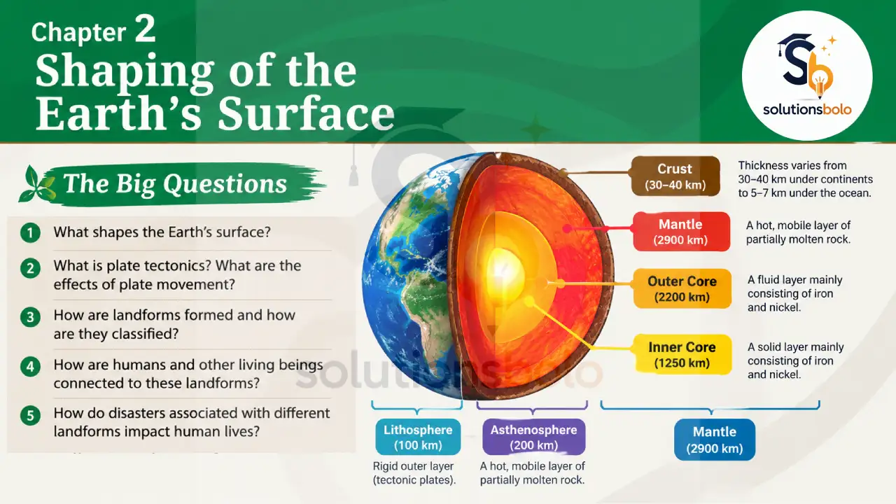
Tectonic Plates: Large, rigid pieces of the Earth’s lithosphere that slowly move over the asthenosphere.
Continental Plates: Tectonic plates mainly made of continental crust, which forms the Earth’s continents.
Oceanic Plates: Tectonic plates mainly made of oceanic crust lying beneath the oceans.
Mixed Plates: Tectonic plates containing both continental and oceanic crust.
Lithosphere: The rigid outer layer of the Earth made up of the crust and the uppermost mantle.
Asthenosphere: A soft, semi-molten layer beneath the lithosphere on which tectonic plates move.
Convection Currents: Slow circular movements of molten material inside the mantle that drive tectonic plate movement.
Plate Boundaries: The regions where two tectonic plates meet and interact.
Convergent Boundary: A plate boundary where two tectonic plates move towards each other.
Divergent Boundary: A plate boundary where two tectonic plates move away from each other.
Transform Boundary: A plate boundary where two tectonic plates slide past one another.
Ring of Fire: A belt around the Pacific Ocean where earthquakes and volcanoes occur frequently.
Volcano: An opening in the Earth’s crust through which magma, gases and ash escape.
Magma: Hot molten rock found beneath the Earth’s surface.
Lava: Molten rock that reaches the Earth’s surface during a volcanic eruption.
Epicentre: The point on the Earth’s surface directly above the earthquake’s focus.
Hypocentre (Focus): The point inside the Earth where an earthquake begins.
Physical Weathering: The breaking of rocks into smaller pieces without changing their chemical composition.
Chemical Weathering: The decomposition of rocks due to chemical reactions with water, air or minerals.
Biological Weathering: The breakdown of rocks by plants, animals and other living organisms.
Water Erosion: The wearing away and transportation of soil and rocks by running water.
Wind Erosion: The removal and movement of loose soil and sand by wind.
Glacier Erosion: The wearing away of rocks and land by the movement of glaciers.
Coastal Erosion: The wearing away of coastlines by sea waves and ocean currents.
Agents of Gradation: Natural forces such as rivers, glaciers, wind, waves and underground water that shape the Earth’s surface.
Contour Ploughing: A farming method in which crops are planted along contour lines to reduce soil erosion.
Bunding: The construction of small embankments to conserve soil and rainwater.
Terracing: The practice of cutting step-like fields on hill slopes to reduce soil erosion.
V-shaped Valley: A narrow valley formed by the downward erosion of a fast-flowing river.
Meander: A broad bend or curve formed in the course of a river.
Oxbow Lake: A crescent-shaped lake formed when a river meander is cut off.
Sea Cliff: A steep rocky face formed along the coastline by wave erosion.
Sea Cave: A hollow opening formed in coastal rocks by continuous wave action.
Sea Arch: A natural arch formed when waves erode a sea cave through a headland.
Sea Stack: A tall isolated rock left standing after a sea arch collapses.
Wave-cut Platform: A flat rocky surface formed at the base of a sea cliff due to wave erosion.
U-shaped Valley: A wide valley carved by the movement of a glacier.
Hanging Valley: A smaller valley that joins a deeper glacial valley at a higher level.
Fjord: A long, narrow sea inlet formed when seawater fills a glacial valley.
Arête: A sharp ridge formed between two glacial valleys.
Moraine: A ridge or mound of rocks and soil deposited by a glacier.
Yardang: A long, narrow ridge carved by wind erosion in dry regions.
Barchan Dune: A crescent-shaped sand dune formed by wind in deserts.
Stalactite: A mineral deposit hanging from the roof of a limestone cave.
Sinkhole: A depression formed when the roof of an underground cave collapses.
NCERT Intext Questions and Answers
1. What shapes the Earth’s surface?
Answer: The Earth’s surface is shaped by internal forces, such as plate movements and volcanic activity and external forces like weathering, erosion, rivers, glaciers, wind and sea waves. Together, these forces continuously create and modify landforms.
Explanation: The Earth’s surface is constantly changing due to the combined action of internal and external forces. Internal forces, including plate tectonics, earthquakes and volcanic eruptions, build mountains, valleys and plateaus. External forces such as weathering, erosion, rivers, glaciers, wind and sea waves gradually wear down rocks and reshape the land. For example, the Himalayas were formed by plate movements, while rivers like the Ganga continuously reshape the plains.
2. What is plate tectonics? What are the effects of plate movement?
Answer: Plate tectonics is the theory that the Earth’s lithosphere is divided into moving tectonic plates. Their movement forms mountains, causes earthquakes and volcanoes, creates ocean basins and continuously reshapes the Earth’s surface over time.
Explanation: Plate tectonics explains that the Earth’s lithosphere consists of large tectonic plates that slowly move over the asthenosphere due to convection currents. When these plates collide, separate or slide past each other, they create mountains, earthquakes, volcanoes and ocean trenches. For example, the collision of the Indian Plate with the Eurasian Plate formed the Himalayas, while the Pacific Ring of Fire experiences frequent earthquakes and volcanic eruptions.
3. How are landforms formed and how are they classified?
Answer: Landforms are formed by internal forces, such as tectonic movements and external forces, including weathering and erosion. They are broadly classified into mountains, plateaus, plains, valleys, deserts, coastal landforms and glacial landforms.
Explanation: Landforms develop through the combined action of internal and external forces acting over millions of years. Plate movements build mountains and plateaus, while rivers, glaciers, wind, waves and underground water gradually shape the landscape through erosion and deposition. Landforms are commonly classified as mountains, plains, plateaus, valleys, coastal landforms, glacial landforms and desert landforms. For example, the Sundarbans Delta was formed by river deposition.
4. How are humans and other living beings connected to these landforms?
Answer: Landforms influence where people live, the crops they grow, available resources, transport and occupations. They also provide habitats for plants and animals, making them essential for human life, biodiversity and sustainable development.
Explanation: Landforms directly affect human life and the natural environment. Mountains provide water and forests, plains support agriculture, plateaus contain valuable minerals and coastal regions encourage fishing and trade. Different landforms also provide habitats for diverse plants and animals. For example, the fertile Indo-Gangetic Plain supports large-scale farming, while the Himalayas supply rivers that sustain millions of people.
5. How do disasters associated with different landforms impact human lives?
Answer: Disasters related to different landforms, such as earthquakes, landslides, floods, avalanches and volcanic eruptions, damage lives, property, agriculture, transport and the environment. They also cause displacement, economic losses and long-term social challenges.
Explanation: Different landforms are associated with different natural disasters that can seriously affect human life. Earthquakes damage buildings, floods destroy crops and settlements, avalanches block transport and volcanic eruptions threaten nearby communities. These disasters also disrupt livelihoods, communication and essential services. For example, the 2013 Kedarnath floods in Uttarakhand caused widespread destruction, highlighting the importance of disaster preparedness and sustainable land use.
6. Can you find out which region is more vulnerable to earthquakes?
Answer: The Himalayan region and the northeastern states of India are the most earthquake-prone areas. Parts of Gujarat, Jammu and Kashmir, Himachal Pradesh, Uttarakhand, Bihar and the Andaman and Nicobar Islands are also highly vulnerable.
Explanation: Regions located near active tectonic plate boundaries are more vulnerable to earthquakes. In India, the Himalayan belt, northeastern states, parts of Gujarat, Jammu and Kashmir, Himachal Pradesh, Uttarakhand, Bihar and the Andaman and Nicobar Islands face higher earthquake risks because of continuous tectonic plate movements. For example, the 2001 Bhuj earthquake in Gujarat caused severe damage and loss of life.
7. Why do you think human lives are at risk?
Answer: Human lives are at risk because natural disasters can occur suddenly, damaging buildings, roads and essential services. Dense populations, weak infrastructure and lack of preparedness increase casualties and make rescue operations more difficult.
Explanation: Human lives become vulnerable when natural disasters strike populated areas. Poorly constructed buildings, overcrowded settlements, lack of early warning systems and inadequate disaster preparedness increase the risk of injuries and deaths. Secondary hazards such as landslides, fires and floods may worsen the situation. For example, strong earthquakes can cause buildings to collapse within seconds, trapping people inside.
8. What do you think caused this situation?
Answer: This situation was most likely caused by powerful internal forces within the Earth, such as tectonic plate movement or volcanic activity. These natural processes release enormous energy, leading to earthquakes, eruptions and changes in the landscape.
Explanation: The situation was probably caused by the movement of tectonic plates beneath the Earth’s surface. When plates collide, separate or slide past one another, they release energy that may trigger earthquakes or volcanic eruptions. These internal forces continuously reshape the Earth’s surface over long periods. For example, the eruption of a volcano releases ash, gases and lava, transforming the surrounding landscape.
9. What could that grey powder be?
Answer: The grey powder is most likely volcanic ash. It consists of tiny rock particles, minerals and volcanic glass released during a volcanic eruption. It spreads over large areas and affects people, crops, transport and the environment.
Explanation: The grey powder is called volcanic ash, which is produced during a volcanic eruption. It contains fine fragments of rocks, minerals and volcanic glass thrown into the atmosphere. Volcanic ash can reduce visibility, damage crops, affect air travel and cause breathing problems. For example, ash from volcanic eruptions in Iceland has disrupted air traffic across Europe on several occasions.
10. What does it tell us about the Earth’s internal forces?
Answer: It shows that the Earth is dynamic and constantly changing. Internal forces generated by heat and tectonic plate movements cause earthquakes, volcanic eruptions, mountain building and other changes that continuously reshape the Earth’s surface.
Explanation: The presence of volcanic ash and related activities shows that powerful internal forces are continuously active beneath the Earth’s surface. Heat from the Earth’s interior drives the movement of tectonic plates, leading to earthquakes, volcanic eruptions and mountain formation. For example, volcanic eruptions release magma and ash, proving that the Earth’s interior remains active and constantly reshapes the planet.
11. Examine the plate map (Fig. 2.3) with the earthquake and volcano map (Fig. 2.4). What correlation do you observe?
Answer: The maps show that most earthquakes and volcanoes occur along tectonic plate boundaries. Regions where plates meet experience frequent seismic and volcanic activity because of continuous plate movement and the release of internal energy.
Explanation: A clear relationship can be observed between tectonic plate boundaries and the distribution of earthquakes and volcanoes. Most seismic and volcanic activities occur where plates collide, separate or slide past one another. These regions experience frequent geological activity due to constant plate movement. For example, the Pacific Ring of Fire records the highest number of earthquakes and active volcanoes in the world.
12. Observe the map showing the distribution of earthquakes and volcanoes (Fig. 2.4). Can you identify which continents and countries are located around the Ring of Fire with the help of an atlas or a globe?
Answer: The Ring of Fire surrounds the Pacific Ocean and includes parts of Asia, North America, South America and Oceania. Countries such as Japan, Indonesia, the Philippines, Chile, the United States and New Zealand lie within it.
Explanation: The Pacific Ring of Fire extends around the Pacific Ocean, passing through Asia, North America, South America and Oceania. Countries including Japan, Indonesia, the Philippines, Chile, the United States, Mexico, Peru and New Zealand frequently experience earthquakes and volcanic eruptions because they lie near active tectonic plate boundaries. This makes the Ring of Fire the world’s most geologically active region.
13. Have you heard about the Sundarbans delta? Try and explore its uniqueness and find out why it is popular with tourists.
Answer: Yes, the Sundarbans is the world’s largest delta, formed by the Ganga, Brahmaputra and Meghna rivers. It is famous for its mangrove forests, Royal Bengal Tigers, rich biodiversity and UNESCO World Heritage status.
Explanation: The Sundarbans Delta, located in India and Bangladesh, is the world’s largest river delta. It is formed by the Ganga, Brahmaputra and Meghna rivers and is covered with dense mangrove forests. The region is home to the famous Royal Bengal Tiger and many unique plant and animal species. Its rich biodiversity, scenic waterways and UNESCO World Heritage status make it a popular tourist destination.
14. Can you find out the reasons that led to the sudden and unexpected flood?
Answer: The sudden flood was likely caused by a Glacial Lake Outburst Flood (GLOF), heavy rainfall or the sudden failure of a natural dam. Climate change and melting glaciers have increased the risk of such floods.
Explanation: A sudden and unexpected flood may occur due to a Glacial Lake Outburst Flood (GLOF), where a glacial lake bursts and releases a huge volume of water. Heavy rainfall, cloudbursts or the collapse of natural barriers can also trigger such floods. For example, Himalayan regions have experienced devastating GLOFs that caused severe damage to villages, roads and bridges.
15. Observe the landforms around your school or residence and try to identify which agent may have created them.
Answer: The landforms around my locality include flat plains and small drainage channels. They were mainly shaped by running water, while weathering and human activities have also contributed to gradual changes in the landscape.
Explanation: Around my school and residence, I observe flat land, fields and drainage channels. These landforms have mainly been shaped by the action of running water, which erodes, transports and deposits soil over time. Weathering and human activities such as construction and farming have also modified the landscape. The exact agent may vary depending on the geographical location of the student’s locality.
16. Complete the exercises given at the end of each type of disaster with the help of newspapers, atlases and books. Make a list of disaster-prone areas from India and the world and enlist mitigation measures quoting recent examples.
Answer: Sample Answer: Disaster-prone areas include the Himalayas, Assam, Gujarat, Japan, Indonesia and Chile. Mitigation measures include early warning systems, disaster-resistant buildings, evacuation plans, afforestation, public awareness and regular disaster management training.
Explanation: Sample Answer: In India, the Himalayan region, Assam, Gujarat, Odisha and the Andaman and Nicobar Islands are prone to earthquakes, floods, cyclones and landslides. Globally, Japan, Indonesia, Chile and the Philippines frequently experience earthquakes and volcanic eruptions. Mitigation measures include early warning systems, earthquake-resistant construction, afforestation, disaster preparedness drills, evacuation planning and community awareness programmes to reduce risks and save lives.
Exercise Questions and Solutions:
1. What are the sources of energy that are required to cause movements associated with the internal forces of the Earth?
Answer: The Earth’s internal movements are powered mainly by heat generated from radioactive decay and the planet’s residual heat. These energy sources create convection currents in the mantle, causing tectonic plate movement, earthquakes, volcanoes and mountain formation.
Explanation: The movements associated with the Earth’s internal forces are driven by enormous amounts of energy generated inside the Earth. Two major sources of this energy are the residual heat left from the Earth’s formation and the heat produced by the radioactive decay of elements present deep within the Earth’s interior. This heat creates convection currents in the semi-molten mantle, causing tectonic plates to move slowly over the asthenosphere.
As these plates collide, separate or slide past one another, they produce earthquakes, volcanic eruptions, mountain ranges and ocean basins. These processes are known as endogenic forces because they originate within the Earth. For example, the collision of the Indian Plate with the Eurasian Plate formed the Himalayas, while plate movement around the Pacific Ring of Fire causes frequent earthquakes and volcanic eruptions.
2. Relate various physiographic divisions you have studied in the earlier grades with various endogenic forces responsible for their origin.
Answer: Different physiographic divisions were formed by different endogenic forces. Mountain ranges formed through plate collisions, plateaus developed due to uplift or volcanic activity, while rift valleys and volcanic regions resulted from tectonic movements beneath the Earth’s surface.
Explanation: India’s major physiographic divisions have been shaped by various endogenic forces acting over millions of years. The Himalayan Mountains were formed by the collision of the Indian Plate with the Eurasian Plate. The Deccan Plateau developed mainly through extensive volcanic activity and lava flows. Rift valleys were formed where tectonic plates moved apart or the Earth’s crust fractured due to internal forces.
These landforms show that the Earth’s surface is constantly changing because of tectonic movements occurring beneath it. Understanding their origin helps explain the relationship between plate tectonics and the physical features we see today. For example, the Himalayas continue to rise slowly because the Indian Plate is still moving towards the Eurasian Plate.
3. Why and where do earthquakes occur frequently? Is it possible to predict earthquakes?
Answer: Earthquakes occur mainly along tectonic plate boundaries where plates collide, separate or slide past each other. Scientists cannot accurately predict earthquakes, but modern technology helps monitor seismic activity and reduce disaster risks through preparedness.
Explanation: Earthquakes occur most frequently along tectonic plate boundaries, where enormous pressure builds up as plates collide, move apart or slide past one another. When this pressure is suddenly released, seismic waves travel through the Earth, causing an earthquake. Regions around the Pacific Ring of Fire, the Himalayan belt, Japan, Indonesia, Chile and parts of western North America experience frequent earthquakes because they lie near active plate boundaries.
Although scientists continuously monitor seismic activity using advanced instruments, accurately predicting the exact time, location and magnitude of an earthquake is still not possible. However, earthquake monitoring, hazard mapping, early warning systems, earthquake-resistant buildings and public awareness programmes help reduce the loss of life and property. For example, Japan’s strict building standards and disaster preparedness have significantly reduced the impact of many earthquakes.
4. “Plate movements are responsible for the distribution of earthquakes and volcanoes.” Explain.
Answer: Plate movements cause earthquakes and volcanoes mainly along plate boundaries. When plates collide, separate or slide past each other, enormous energy is released, leading to earthquakes, volcanic eruptions and continuous changes in the Earth’s surface.
Explanation: The Earth’s lithosphere is divided into large tectonic plates that move slowly over the asthenosphere due to convection currents in the mantle. Most earthquakes and volcanoes occur along plate boundaries, where these plates interact.
At convergent boundaries, colliding plates cause powerful earthquakes and volcanic eruptions. At divergent boundaries, plates move apart, allowing magma to rise and form new crust. At transform boundaries, plates slide past one another, producing frequent earthquakes.
This explains why earthquakes and volcanoes are not randomly distributed but are concentrated along plate margins. For example, the Pacific Ring of Fire contains about 75% of the world’s active volcanoes and experiences frequent earthquakes because it lies along several active plate boundaries. Thus, plate tectonics is the primary reason for the global distribution of earthquakes and volcanoes.
5. Draw and label a diagram of a meander and a delta.
Answer: A meander is a winding bend formed in the course of a river due to erosion and deposition. A delta is a triangular landform formed when a river deposits sediments at its mouth before entering a sea or lake.
Explanation: A meander is a broad, looping bend in a river, usually formed in the middle or lower course due to continuous erosion on the outer bank and deposition on the inner bank. Over time, repeated meanders may even form an oxbow lake.
A delta is formed at the mouth of a river when the river slows down and deposits large amounts of sediments before entering a sea or lake. Deltas are generally fertile and support agriculture and rich biodiversity. For example, the Sundarbans Delta, formed by the Ganga, Brahmaputra and Meghna rivers, is the world’s largest delta.
Simple Diagrams
(a) Meander
(b) Delta
(image will be upload shortly)
6. How are deforestation and erosion associated with each other? Explain.
Answer: Deforestation increases soil erosion because trees bind the soil with their roots. When forests are cleared, rainwater and wind easily remove fertile topsoil, reducing land productivity and increasing the risk of floods and landslides.
Explanation: Deforestation and soil erosion are closely connected. Trees and other vegetation protect the soil by holding it together with their roots and reducing the impact of rain and wind. When forests are cut down, the soil becomes loose and exposed. Heavy rainfall washes away the fertile topsoil, while strong winds carry away dry soil particles.
As a result, agricultural productivity decreases, rivers become filled with sediments and the chances of floods and landslides increase. Deforestation also disturbs the natural balance of the ecosystem and reduces biodiversity. For example, large-scale deforestation in hilly regions often leads to severe soil erosion and frequent landslides during the rainy season. Therefore, protecting forests is one of the most effective ways to control soil erosion.
7. Develop a plan to protect the land in your local area from erosion.
Answer: Land erosion can be reduced by planting more trees, preventing deforestation, practising contour ploughing and terracing, building bunds, improving drainage and creating public awareness about soil conservation and sustainable land management.
Explanation: Sample Plan to Prevent Land Erosion
To protect land from erosion in my locality, I would encourage large-scale tree plantation to strengthen the soil and reduce the impact of rain and wind. Farmers should adopt contour ploughing, terracing and bunding to prevent the loss of fertile soil. Proper drainage systems should be developed to control rainwater runoff and prevent waterlogging.
Awareness programmes can educate people about avoiding unnecessary deforestation and protecting natural vegetation. Local authorities should regularly inspect erosion-prone areas and take preventive measures before the rainy season. For example, planting trees along riverbanks and roadsides can effectively reduce soil erosion and improve environmental sustainability.
8. Which disasters do you think you might experience in your region? Discuss a mitigation plan in your classroom.
Answer: My region may experience floods, cyclones, earthquakes or heatwaves, depending on its location. Disaster preparedness, early warning systems, emergency kits, safe shelters, awareness programmes and regular mock drills can help reduce risks.
Explanation: The disasters likely to affect my region depend on its geographical location. In many parts of India, people may experience floods, cyclones, earthquakes, landslides, droughts or heatwaves. To reduce their impact, communities should prepare a disaster management plan that includes early warning systems, safe evacuation routes, emergency shelters, first-aid kits and regular mock drills.
People should follow official weather warnings, avoid risky areas during disasters and help vulnerable groups such as children and the elderly. Schools can organise awareness programmes to teach students how to respond during emergencies. For example, timely evacuation before Cyclone Fani in Odisha helped save thousands of lives, showing how preparedness can greatly reduce disaster losses.
Project & Activity Questions:
9. Prepare a model of landforms created by underground water.
Answer: Prepare a model showing underground water landforms such as stalactites, stalagmites, caves and sinkholes using clay, cardboard and colours. Label each feature clearly to explain how underground water shapes the Earth’s surface.
Explanation: To prepare a model of landforms created by underground water, take a cardboard base and use clay or modelling dough to make a limestone cave. Create stalactites hanging from the cave roof and stalagmites rising from the cave floor. Add a sinkhole on the surface to show how underground water dissolves limestone rocks and causes the ground to collapse. Label each landform neatly and use colours to make the model attractive. This activity helps students understand how underground water gradually forms unique landforms through the process of chemical weathering and erosion.
10. What precautionary measures will you take if you are staying in an earthquake-prone region?
Answer: In an earthquake-prone region, I would follow safety guidelines, stay away from weak buildings, prepare an emergency kit, practise evacuation drills, secure heavy furniture and remain calm by following official instructions during emergencies.
Explanation: If I lived in an earthquake-prone region, I would ensure that my home is built or strengthened according to earthquake-resistant construction standards. I would keep an emergency kit containing water, food, medicines, a flashlight and important documents. During an earthquake, I would follow the “Drop, Cover and Hold On” safety rule, stay away from windows, heavy furniture and electric poles and avoid using lifts.
After the earthquake, I would move to an open area, check for injuries and follow the instructions issued by disaster management authorities. Regular mock drills and awareness programmes would help my family remain prepared. For example, Japan’s earthquake preparedness programmes and strict building regulations have greatly reduced the loss of life during many earthquakes.
11. Prepare a map showing landform-associated disasters that happened in the current calendar year.
Answer: Prepare an outline map of India and mark regions affected by recent landform-related disasters such as earthquakes, floods, landslides, cyclones or Glacial Lake Outburst Floods (GLOFs). Label each location and mention the disaster briefly.
Explanation: Draw an outline map of India and identify areas affected by landform-associated disasters during the current calendar year. Use different colours or symbols to represent earthquakes, floods, landslides, cyclones, avalanches or GLOFs. Label each location and write a short note explaining the disaster and its impact.
As this activity depends on current events, students should collect information from newspapers, government reports, reliable news websites or disaster management agencies before preparing the map. This activity develops geographical awareness, map-reading skills and an understanding of how different landforms influence natural disasters.
12. Create a poster showing landforms that are considered to be sacred or important in your region and add the folk stories associated with them.
Answer: Create a colourful poster showing important landforms in your region, such as rivers, hills, mountains or caves. Add their cultural or religious importance along with a short folk story or local legend related to each.
Explanation: Sample Answer: Prepare a creative poster featuring landforms that are culturally, historically or religiously important in your region. Include photographs or drawings of rivers, mountains, hills, caves, lakes or forests and briefly explain their significance. Add local folk stories, legends or traditional beliefs associated with these places to make the poster more interesting.
For example, students from Uttarakhand may include the Himalayas and the story of Kedarnath, while students from West Bengal may feature the Sundarbans and the folk traditions surrounding Bonbibi. Students from Tamil Nadu, Maharashtra or other regions can select landforms that are locally important. This activity helps connect Geography with local culture and heritage.
13. Document a case of a disaster that hit your region in the past, highlighting its effects on various human activities.
Answer: Document a disaster that occurred in your region, describe its causes, affected areas, impact on people’s lives, transport, agriculture, businesses, education and the environment and mention the lessons learned and preventive measures adopted.
Explanation: Choose a natural disaster that occurred in your locality or state, such as a flood, cyclone, earthquake, landslide or drought. Mention when and where it happened, its main causes and the areas affected. Describe how it disrupted transportation, agriculture, schools, businesses, communication, healthcare and daily life. Also explain the rescue and relief work carried out by the government and local communities.
For example, students from West Bengal may write about Cyclone Amphan (2020), while students from Uttarakhand may describe the Kedarnath floods (2013). Conclude the report with lessons learned and measures that can reduce the impact of similar disasters in the future.
14. Translate the given poster on landslide into your native language and display it in your home.
Answer: Translate the landslide safety instructions into your native language using simple and clear words. Display the poster at home so that family members can easily understand and follow the safety precautions during emergencies.
Explanation: Read each safety instruction on the landslide awareness poster carefully and translate it into your native language using simple, accurate and easy-to-understand words. Preserve the meaning of every instruction while avoiding difficult vocabulary. After completing the translation, decorate the poster with suitable colours or illustrations and display it at home or in your classroom. This activity promotes disaster awareness, encourages family participation and helps everyone understand the precautions to follow before, during and after a landslide.
15. Divide the class into three groups. Each group will work on one project (water, wind and glacier). The project should highlight the causes, impact on human life and the environment and mitigation measures.
Answer: Divide the class into three groups to study water, wind and glaciers. Each group should explain their causes, effects on people and the environment and suggest practical measures to reduce disaster risks.
Explanation: Form three groups and assign one topic to each: Running Water, Wind and Glaciers.
• Group 1 – Water: Explain floods, river erosion and deposition. Describe their impact on agriculture, settlements, transport and suggest measures like embankments, afforestation and flood warning systems.
• Group 2 – Wind: Study wind erosion, dust storms and sand dunes. Explain their effects on farming, health and transport. Suggest tree plantation, shelter belts and soil conservation.
• Group 3 – Glaciers: Explain glacier movement, avalanches and Glacial Lake Outburst Floods (GLOFs). Describe their impact on mountain communities and recommend glacier monitoring, early warning systems and safe land-use planning.
Multiple Choice Questions (MCQs)
1. Which force is mainly responsible for the formation of mountains and earthquakes?
A. Wind
B. Running water
C. Internal (Endogenic) forces
D. Sea waves
Answer: C. Internal (Endogenic) forces
Explanation:
Internal or endogenic forces originate inside the Earth. They cause tectonic plate movements, earthquakes, volcanic eruptions and mountain formation. These forces continuously reshape the Earth’s surface over millions of years.
2. The movement of tectonic plates is mainly caused by:
A. Ocean currents
B. Convection currents in the mantle
C. Rainfall
D. Wind erosion
Answer: B. Convection currents in the mantle
Explanation:
Heat inside the Earth creates convection currents in the mantle. These currents slowly move tectonic plates, leading to earthquakes, volcanic eruptions, mountain building and the continuous reshaping of the Earth’s surface.
3. The Pacific Ring of Fire is famous for:
A. Dense forests
B. Active earthquakes and volcanoes
C. Large deserts
D. Fertile river plains
Answer: B. Active earthquakes and volcanoes
Explanation:
The Pacific Ring of Fire surrounds the Pacific Ocean and contains numerous active plate boundaries. As a result, it experiences the highest concentration of earthquakes and active volcanoes anywhere in the world.
4. Which type of plate boundary forms when two plates collide?
A. Divergent boundary
B. Transform boundary
C. Convergent boundary
D. Passive boundary
Answer: C. Convergent boundary
Explanation:
A convergent boundary forms when two tectonic plates move towards each other. Their collision creates mountain ranges, deep ocean trenches, strong earthquakes and volcanic activity in many regions.
5. Which of the following is an agent of gradation?
A. Running water
B. Moonlight
C. Earthquake
D. Sunlight
Answer: A. Running water
Explanation:
Running water erodes, transports and deposits sediments. It creates landforms such as valleys, floodplains, meanders, oxbow lakes and deltas, making it one of the most important agents of gradation.
6. Which landform is created mainly by river deposition?
A. Delta
B. Sea cave
C. Yardang
D. Fjord
Answer: A. Delta
Explanation:
A delta forms when a river slows down near its mouth and deposits sediments before entering a sea or lake. These fertile landforms often support agriculture and rich biodiversity.
7. Which landform is commonly formed by glaciers?
A. Sand dune
B. U-shaped valley
C. Meander
D. Sea arch
Answer: B. U-shaped valley
Explanation:
Moving glaciers erode valleys into broad U-shaped forms. They also create hanging valleys, fjords, moraines and other distinctive glacial landforms in mountainous regions.
8. Yardangs and barchan dunes are mainly formed by:
A. Running water
B. Underground water
C. Wind
D. Sea waves
Answer: C. Wind
Explanation:
Wind erodes, transports and deposits sand in dry regions. This process creates unique desert landforms such as yardangs, barchan dunes and sand ridges over long periods.
9. Stalactites and stalagmites are formed by:
A. Running water
B. Underground water
C. Wind
D. Glaciers
Answer: B. Underground water
Explanation:
Underground water dissolves limestone and deposits minerals inside caves. Over time, these deposits form stalactites hanging from cave roofs and stalagmites rising from cave floors.
10. Which disaster is commonly associated with steep mountain slopes?
A. Cyclone
B. Landslide
C. Tornado
D. Tsunami
Answer: B. Landslide
Explanation:
Landslides occur when rocks and soil suddenly move downhill due to heavy rainfall, earthquakes, deforestation or human activities. They often damage roads, homes and communication networks.
11. Which process involves the breaking down of rocks without changing their chemical composition?
A. Chemical weathering
B. Physical weathering
C. Biological weathering
D. Deposition
Answer: B. Physical weathering
Explanation:
Physical weathering breaks rocks into smaller pieces through temperature changes, freezing and pressure without altering their chemical composition. It prepares rocks for further erosion by natural agents.
12. Which Indian mountain range is still rising due to active plate movement?
A. Aravalli Range
B. Vindhya Range
C. Himalayas
D. Satpura Range
Answer: C. Himalayas
Explanation:
The Himalayas continue to rise because the Indian Plate is still moving towards the Eurasian Plate. This ongoing collision also makes the Himalayan region highly vulnerable to earthquakes.
13. Which of the following helps reduce soil erosion most effectively?
A. Deforestation
B. Mining
C. Afforestation
D. Quarrying
Answer: C. Afforestation
Explanation:
Trees hold soil firmly with their roots, reducing erosion caused by rain and wind. Afforestation also conserves biodiversity, improves groundwater recharge and supports sustainable environmental development.
14. A Glacial Lake Outburst Flood (GLOF) occurs when:
A. A glacier suddenly melts completely
B. A glacial lake suddenly bursts
C. A river changes its course
D. Sea level rises rapidly
Answer: B. A glacial lake suddenly bursts
Explanation:
A GLOF occurs when a glacial lake suddenly releases a huge volume of water after its natural dam fails. These floods can devastate mountain communities and infrastructure downstream.
15. Which statement best explains the relationship between earthquakes and volcanoes?
A. They occur randomly across the Earth.
B. They are mostly found along tectonic plate boundaries.
C. They occur only on continents.
D. They are caused by weather conditions.
Answer: B. They are mostly found along tectonic plate boundaries.
Explanation:
Earthquakes and volcanoes are concentrated near tectonic plate boundaries where plates collide, separate or slide past each other. Plate movement releases energy and magma, producing intense geological activity.
Assertion–Reason MCQs
1. Assertion (A): Most earthquakes occur along tectonic plate boundaries.
Reason (R): Plate boundaries are regions where tectonic plates interact and release energy.
A. Both A and R are true and R is the correct explanation of A.
B. Both A and R are true, but R is not the correct explanation.
C. A is true, but R is false.
D. A is false, but R is true.
Answer: A
Explanation: Plate boundaries are zones where plates collide, separate or slide past each other. These movements release enormous energy, causing earthquakes. Therefore, most earthquakes occur near active plate boundaries.
2. Assertion (A): The Himalayas are still rising today.
Reason (R): The Indian Plate continues to move towards the Eurasian Plate.
A. Both A and R are true and R is the correct explanation of A.
B. Both A and R are true, but R is not the correct explanation.
C. A is true, but R is false.
D. A is false, but R is true.
Answer: A.
Explanation: The Indian Plate is continuously colliding with the Eurasian Plate. This ongoing collision uplifts the Himalayas and also makes the region highly prone to earthquakes.
3. Assertion (A): Deforestation increases soil erosion.
Reason (R): Tree roots bind the soil and reduce the impact of rain and wind.
A. Both A and R are true and R is the correct explanation of A.
B. Both A and R are true, but R is not the correct explanation.
C. A is true, but R is false.
D. A is false, but R is true.
Answer: A.
Explanation: Trees hold soil firmly through their roots. When forests are removed, loose soil is easily carried away by water and wind, increasing soil erosion and reducing land productivity.
4. Assertion (A): Deltas are fertile landforms.
Reason (R): Rivers deposit fine sediments at their mouths.
A. Both A and R are true and R is the correct explanation of A.
B. Both A and R are true, but R is not the correct explanation.
C. A is true, but R is false.
D. A is false, but R is true.
Answer: A.
Explanation: As rivers slow near their mouths, they deposit nutrient-rich sediments. These deposits form fertile deltas that support intensive agriculture and dense human settlements.
5. Assertion (A): Wind is an important agent of erosion in deserts.
Reason (R): Deserts usually have little vegetation to protect the soil.
A. Both A and R are true and R is the correct explanation of A.
B. Both A and R are true, but R is not the correct explanation.
C. A is true, but R is false.
D. A is false, but R is true.
Answer: A.
Explanation: In deserts, the absence of vegetation allows strong winds to remove and transport loose sand easily, creating dunes, yardangs and other wind-shaped landforms.
6. Assertion (A): Glacial Lake Outburst Floods (GLOFs) are dangerous.
Reason (R): They suddenly release huge quantities of water downstream.
A. Both A and R are true and R is the correct explanation of A.
B. Both A and R are true, but R is not the correct explanation.
C. A is true, but R is false.
D. A is false, but R is true.
Answer: A.
Explanation: When a natural dam holding a glacial lake breaks, massive amounts of water rush downstream, causing destructive floods that threaten lives, infrastructure and ecosystems.
7. Assertion (A): Weathering and erosion are the same process.
Reason (R): Weathering breaks rocks in place, while erosion transports the broken materials.
A. Both A and R are true, but R is not the correct explanation.
B. A is true, but R is false.
C. A is false, but R is true.
D. Both A and R are false.
Answer: C.
Explanation: Weathering and erosion are different processes. Weathering breaks rocks at their original location, whereas erosion removes and transports the weathered materials through water, wind, glaciers or waves.
Case-Based MCQs:
Case Study 1
Heavy rainfall triggered a landslide in a hilly region after large numbers of trees had been cut down for road construction. The landslide blocked highways, damaged houses and disrupted transport.
8. Which factor mainly increased the risk of the landslide?
A. Afforestation
B. Deforestation
C. River deposition
D. Coastal erosion
Answer: B. Deforestation
Explanation: Tree roots strengthen slopes by holding soil together. Removing forests weakens the land, making it more vulnerable to landslides, especially during heavy rainfall.
9. Which measure would best reduce similar disasters in the future?
A. Cutting more trees
B. Increasing mining
C. Afforestation and slope protection
D. Building more roads without planning
Answer: C. Afforestation and slope protection
Explanation: Planting trees, stabilising slopes and following proper construction practices reduce soil erosion and landslides, protecting people, roads and the surrounding environment.
Case Study 2
Scientists observed frequent earthquakes and volcanic eruptions around the Pacific Ocean. They identified this region as the Ring of Fire.
10. Why does the Ring of Fire experience frequent earthquakes?
A. Heavy rainfall
B. Active tectonic plate boundaries
C. Strong winds
D. High temperatures
Answer: B. Active tectonic plate boundaries
Explanation: The Ring of Fire contains several active plate boundaries where tectonic plates collide, separate or slide past each other, producing frequent earthquakes and volcanic eruptions.
11. Which ocean is surrounded by the Ring of Fire?
A. Atlantic Ocean
B. Indian Ocean
C. Pacific Ocean
D. Arctic Ocean
Answer: C. Pacific Ocean
Explanation: The Ring of Fire forms a horseshoe-shaped belt surrounding the Pacific Ocean. It is the world’s most active zone for earthquakes and volcanic activity.
Case Study 3
A river flowing across a plain developed several winding bends. After many years, one bend became separated from the main river, forming a small lake.
12. Which landform was first created by the river?
A. Delta
B. Meander
C. Fjord
D. Yardang
Answer: B. Meander
Explanation: Meanders are winding river bends formed by erosion and deposition. Continued erosion can eventually cut off a meander, creating an oxbow lake.
13. The isolated lake formed from the river bend is called a:
A. Sinkhole
B. Oxbow lake
C. Sea cave
D. Moraine
Answer: B. Oxbow Lake
Explanation: When a river cuts through the narrow neck of a meander, the old bend becomes isolated from the main channel, forming an oxbow lake.
Case Study 4
A mountain region experienced rapid glacier melting. A glacial lake suddenly burst, sending huge amounts of water downstream and destroying roads and villages.
14. Which disaster is described in the passage?
A. Cyclone
B. GLOF (Glacial Lake Outburst Flood)
C. Dust storm
D. Tsunami
Answer: B. GLOF (Glacial Lake Outburst Flood)
Explanation: A GLOF occurs when a glacial lake suddenly bursts due to failure of its natural dam, releasing enormous volumes of water and causing severe flooding in downstream areas.
Competency-Based & Application-Based Questions
1. During the rainy season, a hilly road in your state is frequently blocked by landslides. As a student, what measures would you suggest to reduce such disasters?
Answer: Frequent landslides can be reduced by planting more trees on hill slopes, avoiding unnecessary cutting of forests, constructing retaining walls, improving drainage systems and restricting construction in unstable areas. Authorities should monitor landslide-prone regions and issue timely warnings. Public awareness programmes and proper land-use planning can also reduce risks. For example, afforestation, slope protection and early warning systems together help minimise landslide damage.
2. A farmer notices that the fertile topsoil from his field is washed away after every heavy rainfall. Which geographical process is taking place and how can it be controlled?
Answer: The farmer’s field is experiencing soil erosion caused by running water. This reduces soil fertility and affects crop production. The problem can be controlled through contour ploughing, terracing, bunding, planting trees and maintaining vegetation cover. Proper drainage and avoiding deforestation also help protect the soil. For example, farmers in hilly areas often use terrace farming to reduce soil erosion and conserve fertile land.
3. While travelling through a desert, you observe sand dunes changing their shape over time. Which natural agent is responsible for this change and why?
Answer: Wind is the main agent responsible for changing the shape of sand dunes. Strong winds continuously erode, transport and deposit sand particles from one place to another. Since deserts have little vegetation, loose sand moves easily with the wind. For example, barchan dunes in the Thar Desert gradually shift due to continuous wind action. This shows how wind constantly reshapes desert landscapes.
4. An earthquake has struck a nearby city. What precautions should people take before, during and after an earthquake?
Answer: People should ensure buildings follow earthquake-resistant designs and keep an emergency kit ready. During an earthquake, they should Drop, Cover and Hold On, stay away from windows and avoid using lifts. After the earthquake, they should move to open spaces, help injured people and follow official instructions. For example, regular earthquake drills in schools help students respond safely during emergencies.
5. A river flowing through a plain has developed several meanders over many years. How do these bends affect the surrounding land and people?
Answer: Meanders slow the river’s flow, causing erosion on the outer bank and deposition on the inner bank. Over time, they create fertile floodplains that support agriculture but also increase the risk of flooding during heavy rainfall. For example, rivers such as the Ganga develop meanders that provide fertile soil for farming while occasionally causing floods in nearby villages.
6. Scientists report that glaciers in the Himalayas are melting rapidly due to rising temperatures. What problems may this create for people living downstream?
Answer: Rapid glacier melting can increase the risk of Glacial Lake Outburst Floods (GLOFs), floods, landslides and water shortages in the future. These events may damage roads, bridges, villages, farmland and hydroelectric projects. Governments should monitor glacial lakes and establish early warning systems. For example, recent GLOF incidents in Himalayan regions have highlighted the need for better disaster preparedness and climate action.
7. Your village plans to build houses close to a riverbank because the land is fertile. What factors should people consider before making this decision?
Answer: Before building houses near a river, people should assess flood risks, riverbank erosion, drainage conditions and the area’s disaster history. Safe construction should follow proper planning and avoid flood-prone zones. Vegetation along the riverbank should be protected to reduce erosion. For example, settlements built too close to rivers often suffer severe damage during floods, even though the land is highly fertile.
Long Answer Questions
1. Explain the theory of plate tectonics. Describe the different types of plate boundaries and their role in shaping the Earth’s surface.
Answer: The Theory of Plate Tectonics explains that the Earth’s lithosphere is divided into several large and small tectonic plates that slowly move over the semi-molten asthenosphere. This movement is driven by convection currents generated by heat inside the Earth. These slow but continuous movements reshape the Earth’s surface over millions of years.
There are three main types of plate boundaries:
• Convergent Boundary: Two plates move towards each other. Their collision forms mountain ranges, deep ocean trenches, earthquakes and volcanoes. For example, the collision of the Indian Plate and the Eurasian Plate formed the Himalayas.
• Divergent Boundary: Two plates move away from each other. Magma rises through the gap, creating new crust and underwater mountain ranges.
• Transform Boundary: Two plates slide past one another horizontally. Friction between the plates often causes powerful earthquakes.
Most earthquakes and volcanoes occur near these plate boundaries, especially around the Pacific Ring of Fire. Plate tectonics explains the formation of continents, oceans, mountains, earthquakes and volcanoes, making it one of the most important theories in Geography.
2. Explain the processes of weathering and erosion. How do different agents of gradation shape the Earth’s surface?
Answer: The Earth’s surface is continuously modified by weathering and erosion. Weathering is the breakdown of rocks at their original location, while erosion is the removal and transportation of weathered materials by natural agents.
Weathering is of three types:
Physical Weathering: Rocks break due to temperature changes or freezing.
Chemical Weathering: Rocks decompose through chemical reactions with water, oxygen or acids.
Biological Weathering: Plant roots, animals and microorganisms break rocks apart.
The main agents of gradation include:
Running Water: Forms V-shaped valleys, meanders, oxbow lakes, floodplains and deltas.
Glaciers: Create U-shaped valleys, hanging valleys, fjords and moraines.
Wind: Shapes deserts by forming yardangs and barchan dunes.
Sea Waves: Produce sea cliffs, sea caves, arches, stacks and wave-cut platforms.
Underground Water: Forms caves, stalactites, stalagmites and sinkholes.
Together, these processes continuously wear down, transport and deposit materials, creating diverse landforms across the Earth.
3. Explain how different landforms influence human life. Also discuss the major natural disasters associated with them and the measures to reduce their impact.
Answer: Landforms have a direct influence on where people live, the occupations they follow and how they use natural resources. Mountains provide forests, water sources and tourism opportunities but are vulnerable to earthquakes, landslides, avalanches and Glacial Lake Outburst Floods (GLOFs). Plains support agriculture and dense settlements but are often affected by floods. Plateaus are rich in minerals and encourage mining and industries, while coastal regions promote fishing and trade but face cyclones and coastal erosion.
Natural disasters associated with these landforms can damage lives, property, transport, agriculture and the environment. Their impact can be reduced through afforestation, scientific land-use planning, early warning systems, disaster-resistant construction, proper drainage, public awareness and regular disaster preparedness drills.
For example, Japan has reduced earthquake losses through strict building regulations, while Odisha has successfully minimised cyclone casualties through efficient early warning and evacuation systems. Sustainable development and responsible use of natural resources are essential for reducing disaster risks.
4. Why is disaster preparedness essential? Explain the measures that should be taken before, during and after natural disasters.
Answer: Natural disasters such as earthquakes, floods, landslides, cyclones, avalanches and GLOFs can occur suddenly and cause widespread destruction. Disaster preparedness helps protect lives, reduce economic losses and improve the speed of rescue and recovery operations.
Before a disaster, people should identify hazards, prepare emergency kits, strengthen buildings, plant trees where necessary and participate in awareness programmes and mock drills.
During a disaster, people should remain calm, follow official warnings, move to safe locations, avoid dangerous areas and help children, elderly people and persons with disabilities.
After a disaster, rescue teams should provide first aid, food, water, shelter and medical care. Damaged infrastructure should be repaired and affected communities should receive rehabilitation support. People should also follow government advisories and avoid unsafe structures.
For example, effective disaster preparedness has helped reduce the impact of cyclones in Odisha and earthquakes in Japan. Preparedness, awareness and community participation are key to building disaster-resilient societies.
Common Mistakes & Exam Tips
1. Confusing Weathering with Erosion
Mistake: Treating weathering and erosion as the same process.
Correct Concept: Weathering breaks rocks at their original place, whereas erosion carries the broken materials away through water, wind, glaciers or waves.
2. Mixing Up the Types of Plate Boundaries
Mistake: Confusing convergent, divergent and transform boundaries.
Correct Concept:
Convergent: Plates collide.
Divergent: Plates move apart.
Transform: Plates slide past each other.
Remembering their movements helps explain earthquakes, volcanoes and mountain formation correctly.
3. Thinking Earthquakes Occur Randomly
Mistake: Believing earthquakes can happen anywhere with equal probability.
Correct Concept: Most earthquakes occur near tectonic plate boundaries, especially around the Pacific Ring of Fire and other active fault zones.
4. Confusing Agents of Gradation
Mistake: Forgetting which landforms are created by rivers, glaciers, wind, sea waves or underground water.
Correct Concept:
River: Meanders, oxbow lakes, deltas.
Glacier: U-shaped valleys, moraines, fjords.
Wind: Yardangs, barchan dunes.
Sea Waves: Sea cliffs, arches, stacks.
Underground Water: Stalactites, stalagmites, sinkholes.
5. Ignoring the Role of Deforestation
Mistake: Thinking only heavy rainfall causes soil erosion and landslides.
Correct Concept: Deforestation weakens soil by removing tree roots that hold it together, making erosion and landslides more likely.
6. Confusing Weathering Types
Mistake: Mixing physical, chemical and biological weathering.
Correct Concept:
Physical: Rocks break without changing composition.
Chemical: Minerals change due to chemical reactions.
Biological: Living organisms break rocks.
7. Forgetting Disaster Mitigation Measures
Mistake: Writing only the causes of disasters.
Correct Concept: Always mention preventive measures such as afforestation, early warning systems, disaster-resistant construction, proper drainage and public awareness, especially in long-answer and competency-based questions.
8. Missing Examples in Answers
Mistake: Writing only definitions without examples.
Correct Concept: Add one relevant example whenever possible. For instance: Himalayas – Convergent boundary, Pacific Ring of Fire – Earthquakes and volcanoes, Sundarbans Delta – River deposition, Thar Desert – Wind erosion
Examples make answers stronger and help secure better marks.
Class 9 Social Science Chapter 2 Summary – Shaping of the Earth’s Surface
Chapter 2: Shaping of the Earth’s Surface explains how the Earth’s surface is continuously changing due to the combined action of internal (endogenic) forces and external (exogenic) forces. Internal forces originate deep inside the Earth and are responsible for the movement of tectonic plates, leading to earthquakes, volcanic eruptions and the formation of mountains, plateaus and ocean basins. The chapter introduces the Theory of Plate Tectonics, explaining that the Earth’s lithosphere is divided into several plates that move slowly over the asthenosphere because of convection currents within the mantle. It also describes the three types of plate boundaries—convergent, divergent and transform—and explains how each contributes to the formation of different landforms and natural hazards. The Pacific Ring of Fire is highlighted as one of the world’s most active regions for earthquakes and volcanoes due to intense plate interactions.
The chapter also explains how the Earth’s surface is gradually modified by weathering, erosion, transportation and deposition. Weathering breaks rocks into smaller pieces through physical, chemical and biological processes, while erosion removes and transports these materials. Various agents of gradation—including running water, glaciers, wind, sea waves and underground water—continuously shape the landscape by creating distinctive landforms. Running water forms V-shaped valleys, meanders, oxbow lakes, floodplains and deltas. Glaciers carve U-shaped valleys, hanging valleys, fjords and moraines. Wind creates yardangs and barchan dunes, sea waves produce sea cliffs, caves, arches, stacks and wave-cut platforms, while underground water forms caves, stalactites, stalagmites and sinkholes. These processes constantly reshape the Earth’s surface over long periods.
Another important theme of the chapter is the relationship between landforms and natural disasters. Mountain regions are vulnerable to earthquakes, landslides, avalanches and Glacial Lake Outburst Floods (GLOFs), while river plains often experience floods and coastal areas may face erosion and storm-related hazards. Human activities such as deforestation, unplanned construction and improper land use can increase the impact of these disasters. The chapter emphasises the importance of disaster preparedness, sustainable land management, afforestation, early warning systems and scientific planning to reduce risks and protect both people and the environment.
Overall, this chapter demonstrates that the Earth’s surface is dynamic rather than permanent. It explains how powerful internal forces build landforms, while external forces continuously wear them down and reshape them. By understanding these natural processes and adopting responsible environmental practices, we can better manage natural hazards, conserve landscapes and promote sustainable development.
Frequently Asked Questions (FAQs)
1. What is the main topic of Chapter 2 – Shaping of the Earth’s Surface?
Answer: This chapter explains how the Earth’s surface changes due to internal forces like plate tectonics and external forces such as weathering, erosion, glaciers, rivers, wind, sea waves and underground water. It also discusses landforms, natural disasters and disaster management.
2. What is plate tectonics?
Answer: Plate tectonics is the theory that the Earth’s lithosphere is divided into moving tectonic plates. Their movement causes earthquakes, volcanic eruptions, mountain formation and many other changes on the Earth’s surface.
3. What are the three types of plate boundaries?
Answer: The three types of plate boundaries are convergent, divergent and transform boundaries. These boundaries are responsible for the formation of mountains, ocean ridges, earthquakes and volcanoes.
4. Why is the Pacific Ring of Fire important?
Answer: The Pacific Ring of Fire is important because it contains many active tectonic plate boundaries. As a result, it experiences the highest number of earthquakes and volcanic eruptions in the world.
5. What is the difference between weathering and erosion?
Answer: Weathering breaks rocks into smaller pieces at the same place, while erosion removes and transports those broken materials through water, wind, glaciers or sea waves.
6. What are the main agents of gradation?
Answer: The main agents of gradation are running water, glaciers, wind, sea waves and underground water. They continuously erode, transport and deposit materials to create different landforms.
7. Which landforms are created by rivers?
Answer: Rivers create V-shaped valleys, meanders, oxbow lakes, floodplains and deltas through the processes of erosion, transportation and deposition over long periods.
8. Which landforms are formed by glaciers?
Answer: Glaciers form U-shaped valleys, hanging valleys, fjords, moraines and cirques by slowly moving over the land and eroding rocks beneath them.
9. What is a Glacial Lake Outburst Flood (GLOF)?
Answer: A GLOF is a sudden flood caused when a glacial lake bursts after its natural dam fails. It can cause severe damage to people, roads, bridges and settlements downstream.
10. Why do earthquakes occur frequently in some regions?
Answer: Earthquakes occur more frequently near tectonic plate boundaries because moving plates continuously collide, separate or slide past each other, releasing energy stored within the Earth’s crust.
11. How does deforestation increase soil erosion?
Answer: Trees hold soil firmly with their roots. When forests are cut down, loose soil is easily washed away by rain or blown away by wind, increasing soil erosion and landslide risks.
12. Why is disaster preparedness important?
Answer: Disaster preparedness helps reduce the loss of life and property. It includes early warning systems, emergency planning, public awareness, safe construction and regular disaster management drills.
13. Which natural disasters are discussed in this chapter?
Answer: The chapter discusses earthquakes, landslides, avalanches, Glacial Lake Outburst Floods (GLOFs), floods, coastal erosion and dust storms, along with ways to reduce their impact.
14. Why should students study this chapter?
Answer: This chapter helps students understand how the Earth’s surface changes, how natural disasters occur and how people can reduce risks through scientific planning, environmental conservation and disaster preparedness.
15. Which topics are most important for exams from this chapter?
Answer: Students should focus on plate tectonics, plate boundaries, Ring of Fire, weathering, erosion, agents of gradation, landforms created by different agents, earthquakes, landslides, GLOFs and disaster mitigation measures, as these are the most frequently tested concepts.
16. What is the shape of the Earth in answer?
Answer: The shape of the Earth is an oblate spheroid (often referred to as a geoid), which means it is slightly flattened at the North and South Poles and bulges around the equator due to its rotation.
17. What is meant by shaping of the Earth class 9?
Answer: Shaping of the Earth refers to the continuous transformation of the Earth’s surface caused by internal (endogenic) forces like plate tectonics, earthquakes and volcanism, along with external (exogenic) forces like weathering, erosion and deposition by water, wind, glaciers and waves.
18. Shaping of the earth surface question answer key overview?
Answer: Shaping of the Earth’s surface in Class 9 Social Science involves internal (endogenic) forces like plate tectonics and volcanoes and external (exogenic) agents like water, wind and glaciers that continuously erode and deposit landforms.
19. What are Glacial Lake Outburst Floods (GLOFs)?
Answer: GLOFs are sudden, catastrophic downstream floods caused by the breach or collapse of natural moraine/ice dams holding back high-altitude glacial meltwater lakes.
20. Where can I access Class 9 Social Science Chapter 2 notes and question answers?
Answer: Complete chapter summaries, MCQs, textbook solutions and competency-based questions for Class 9 Chapter 2 are available on Solutions Bolo.
21. What are some extra questions about the shaping of the Earth’s surface for Class 9 Geography?
Answer: Essential extra questions include: defining the asthenosphere, explaining how mantle convection causes plate motion, differentiating between barchans and yardangs and identifying mitigation steps for landslides and GLOFs.
(images will be upload shortly)